")
")
Historian Sigita GASPARAVICIENE
Bishops’ gardens
Let us briefly overview historical development of the major Vilnius historical green spaces and their complexes starting from the very oldest ones.
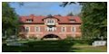
Today’s Presidency Park (former Bishops’ Palace ) is one of the oldest with uninterrupted history. It is associated with the first written mention of this green space in 1387. ”A garden that is located at Goštauto street – A garden by a hillside southwards and a road circling around Vilnius towards the river in the West”. Part of Goštautų gardens territory is today covered with the Presidency Park. The Bishops’ gardens were also mentioned in 1543 letter of Bishop P.Alšėniškis (Holszanski), where he was writing about setting up a chapel in the garden by the Bishop’s Palace. The surviving inventory of 1753 shows that at the time this was an incredibly beautiful "Italian" style park in documents traditionally called the garden. It was developed following the example of Northern Italian parks, and covered a much larger area than it does now. The main park massif was situated in the territory of today’s Daukanto street. The garden of irregular shape was laid out geometrically with straight radial paths, round square and regularly shaped lawns characteristic of the baroque age. The centrepiece of the garden was a large quadrangle pond. In the 18th. C. this was on the most beautiful and interesting Vilnius parks. After the palace was transformed into the residence of Vilnius Governor General the former “Italian” or baroque park was redeveloped according to the design of the Principality architect J.Pusje and expanded westwards and the behind the palace. It was given the structure of the “English” park that came into fashion then. The green space was divided by wall into two independent parts from the composition point of view. The garden layout became more pictorial with new curved alleys and irregularly shaped lawns. The garden was expanded in the Southwest direction and moved from the old part in front of the palace that was now converted into a square. The square had a fountain with an oval pool. In 1898 the former was replaced by a monument of an ex-Governor General of Vilnius M.Murawjow, the suppresser of the 1863 revolt, and the square was named after him (the monument hated by Vilnius citizens was torn down after the 1st World War). After the 1st World War the square was named after Napoleon. Until 1987 the palace park had a 100 trees including maple, oak and chestnut trees much like by Lithuanians since old times.
Lower Castle Palace Park
Vilnius Lower Castle Palace Park. This park is a heritage park of many centuries of development and unique value to Lithuanian history. The Lower Palace garden was on the southern slope of the Castle Hill, to the south and Southeast of the Lower Castle Palace. Little is known of its structure, only that in 1536 it was taken care by gardener J.Hartulanus. There are mentions of alleys, lawns, flowerbeds, white marble sculptures and decorative bridges. At the time it could compete with the most beautiful Italian and French gardens. In time, however, the park deteriorated. After the Lower Castle Palace was torn down at the end of the 18th c. its territory was included into the area of the czar military fort then under development. When the military citadel was set up with ditches dug in the territory of the former park and a shooting range, the destruction of the green spaces of this territory was completed. After the czar fortress was shut down the Lower Castle Palace Park went to the city municipality and was incorporated into the complex of Castle Hill foot green spaces. In about the same spot a square much liked by citizens called Veršynas (Calf-tender) was set up.
![]()
Radvilų Garden
Former Radvilų Garden at the Lower Palace was located by River Neris west of Vingrės stream. It was set up in the 16th c. by Radvilų Palace called the Palace of Barbora Radvilaitė. The garden spread Southeast of the palace and was linked to the Lower Castle palace by a closed bridge-shaped gallery which was a unique thing. The legend has it that Žygimantas Augustas used to visit Barbora Radvilaitė by this gallery. Until the beginning of the 18th c. this was a renaissance park, the style of which the Radvilas remembered from the time of their studies in Italy. The Southeast part of the garden displayed four regularly-shaped ponds with swans raised there for that special purpose. When in the beginning of the 19th c. the palace deteriorated, the garden gradually vanished with it. At the end of the 19th c. the territory was owned by various owners and was gradually developed.
Bernardine Monastery
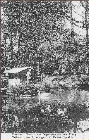
Gardens of former Bernardine Monastery and former Olizar Palace. In as early as the 15th c. the Bernardine (fratres fransiscanes observantes) Monastery had a garden located Northwest of it. This was one of the oldest monastery gardens in Lithuania. And in the 16-17th c. a garden was set up by the adjacent palace which was later called Olizar palace. In the 1st half of the 18th c. both gardens were fenced in by brick walls and paid out in regular straight lines. At the time this must have been the best managed complex of green spaces in Vilnius. It was comprised of four smaller gardens, a few horticultural gardens with a hop-garden, herb gardens, shade lime and maple tree alleys for cutting. In the beginning of the 19th c. the Bernardine Monastery garden retained the regular layout whereas the adjacent Olizar garden was paid out pictorially. When in mid 19th c. a new street was built right through the garden territory (today’s Maironio street), the garden was practically destroyed. The small garden in front of the Lithuanian Arts Academy today is the remains of this garden.
Sapiega Palace Park
Former Sapiega Palace Park in Antakalnis was beautiful not just because it was well maintained and landscaped, but also because of its beautiful surroundings. From the Southeast it was surrounded by hills covered with pinewoods, and in the Northwest the picturesque view of banks of River Neris opened up. The park was set up at the end of the 17th c. between Pilies and Antakalnio streets. This is though to have been a Lithuanian shrine with an oak grove. In the early 18th c. it was of a prolong quadrangle shape with the layout characteristic of the baroque age. The lengthwise alley leading to the palace was construed as the compositional axis of the park. The park was fenced in by a brick wall and had unique gate of a rich baroque style, a part of which survived to this day. This was the heyday of the park. At the end of the 18th c. the park was expanded Southwest. In the 2nd quarter of the 19th c. the park was even further expanded in the same direction and approached the of Latheran Canons’ Monastery garden. The layout of the old part of the park did not see major changes, whereas the new part of the park was re-landscaped pictorially. In mid 19th c. a military hospital with numerous hospital buildings was set up in the park. The structure of the park changed significantly with only the backbone and the oldest lime tree in Vilnius, 19th c. poplars, birch trees and maples surviving to this day.
Latheran Canons’ Monastery
Gardens at the former Latheran Canons’ Monastery in Antakalnis. At the end of the 17th c. a garden was set up at the Pacų Palace which was later on together with the palace handed over to the Latheran Canons’ Monastery. In the 2nd quarter of the 18thh c. a regularly landscaped garden bordering the monastery yard was spreading east of St. Peter and Paul’s Church and the monastery.
At the end of the 18th c. the garden was developing northwards along Antakalnio street. It was prolong and landscaped a strict and regular manner. Its central alley parallel to the street was intersected by perpendicular paths with an oval square with a pool displayed at the intersection of the alley and central path. In the 2nd quarter of the 19th c. the garden was landscaped more pictorially with some of the paths acquiring a curved shape. The garden had pyramid poplars planted in rows, quite a few of which survived by the church into the end of the 19th c. With the expansion of Vilnius and rapid urban development of Antakalnis in mid 19th c., the park deteriorated.
![]()
"Chinese and Tivoli Gardens"
Chinese and Tivoli Gardens in Antakalnis. The Chinese garden was set up by a small palace built in mid 18th c. Northwest of St. Peter and Paul’s church (today’s British Embassy). This oblong garden spread from the bank of River Neris. During the same period another – much larger – Tivoli garden was set up north of St. Peter and Paul’s church (at today’s 6-8 Antakalnio street).At the end of the 18th c. and at the beginning of the 19th c. – during the heyday of both parks – they were landscaped in regular manner with straight parallel and perpendicular paths. In the 2nd quarter of the 19th c. the layout of these gardens was converted into pictorial. A pond with an island and surrounded by a curvy path was built in the Chinese Garden. The landscaping of this garden displayed elements characteristic to the Chinese garden art very fashionable at the time in Europe, which justifies its name. For instance, The Chinese garden had the famous Bohl restaurant. The palace of Tivoli gardens also had a restaurant surrounded by Tivoli lilac bushes (hence the name of the garden) and flower beds. Music was played in the garden in the summertime. In the 1st half of the 19th c. both gardens were much visited. A lot of congregations and parties took place there where a regular guest was poet A.Mickevičius (Adam Mickiewicz). The heyday, however, was short, and ended in mid 19th c. Only separate tree groups survived in the place of former splendid gardens.
Slushka Palace Garden
Former Slushka Palace Garden in Antakalnis. The garden was set up at the end of the 17th&c. Southwest of the palace between today’s T.Kosciuškos street and bank of River Neris. It had geometrical landscaping with clipped box-tree quadrangle mazes and perpendicularly intersecting paths. By the end of the 18th c. this was one of the best maintained “Italian” style Vilnius residential palace parks. With the change in palace ownership, and with the military services taking over the palace at the beginning, the park deteriorated. The only survivor of the garden was a broad landscaped band by the street. Today the undeveloped part of the garden displays a square.
![]()
Missionary Church and Monastery Garden
Former Missionary Church and Monastery Garden. Initially set up in mid 17th c. as a palace park of nobleman and patron of arts J.Sangushka, in 1686 the palace with the park and ponds were donated to missionary monks. It was set on the elevation east of the monastery along Subačiaus street. The garden boasted the famous water springs at the foot of the Saviour’s Mountain, that it time began to be called the Missionaries’ Springs. A wonderful view of Vilnius opened up from here. Horticultural and fruit gardens were located on the hill terrace. The garden layout was strictly regular with almost the same size quadrangular lawns. The central alley was crossed perpendicular by three paths, with the oval square built in the central intersection. In the garden in the valley of River Vilnia there ponds with plenty of fish, the surplus water of which was flowing by underground piping to Vilnia. In mid 19th c. the garden was densely grown with huge trees. In the 19th apple, pear, plum and cherry trees and gooseberry and currant bushes were growing in the garden, and poplars and maple trees in the park. At the beginning of the 20th c. the springs lost their significance, the ponds, though, remained an important element of the park still called the Missionaries’ Park and liked by citizens. In the between-world-war period the park was returned to the missionaries. Old Vilnius citizens recall that the part had a gardener and a pond caretaker. The part was damaged during the 2nd World war, with its further destruction continuing after the War. Part of the Missionaries’ Park became a road that appeared as an extension to Maironio street which severed the park into two parts and disrupted the pond system. The former park territory became a wasteland overgrown with bushes.
The Paradise Garden in Rasų Suburb
The Paradise Garden in Rasų Suburb. The garden spread in a wonderful location where elevations of various grades transiting into Rasų hills, intersected by ditches and springs emerged as a splendid natural view, which in the 19th c. was considered to be one of the most beautiful spots of suburban Vilnius. Untarnished landscape survived until the 20th c. The 1938 Official Plan left Monastery of Visitation nuns and Paradise along with other gardens located here as part of the green space not to be touched.
Since as early as the 18th c. parks and gardens were set up here making use of the nature, interesting landscape and a view opening up from the Rasų Hills. The so called Paradise Garden was known to have been here since as early as the 17th c. Until 1733 it belonged to Jesuits who made it even more beautiful, set up a pond and enclosed it with a fence displaying biblical drawings. Hence the name of the garden. In 1773, after the Jesuit Order was shut down, the Paradise Garden went to Sisters of Mercy Monastery and the shelter of Baby Jesus. During the revolt of 1794 the park suffered great damages, and in the 19th c. it was converted into horticultural gardens.
Korvell and Roėnne Gardens and Parks and other suburban Rasų and Rūdninkų parks. Gardens spreading behind Monastery of Visitation nuns and Paradise garden were owned at different times by noblemen Plater, Czapski, later Korvell. These were regularly landscaped gardens by Rasų street. In the 2nd quarter of the 19th c they expanded in the direction of Rasų cemetery and develop into a huge park-garden known as Korvell Garden. Later the railway construction severed the park into two parts, following which these parts were bought by a banker and patron of arts J.Montvila, who built here a residential block on today’s Balstogės street.
Roėnne Garden was behind Aušros Vartai, the Gate of Dawn, in the southern part of Paradise lane (today’s M.Daukšos street.). Its territory was intersected by Rasų lane, with its eastern pat divided into regular quadrangles, and the western part divided by curved lasso-shaped paths.
Strumilos Gardens spread in a spacious territory, approximately where today we have both parts of Sodų street and extending as far as St. Stephen’s street. The famous gardener theoretician J.Strumila (J.Strumillo) set up his gardens here. The surviving 1845 city map shows that as early as mid 19th c. -after the gardener died - these land plots were sold and rather soon saw housing developments. Some remains of this garden we can still see on the hill between Sodų and St. Stephen’s street, where wonderful views of the Old Town open up as well. The tradition of garden design of Strumila was continued by the Wėller gardeners’ dynasty that bought part of Strumila’s garden land in the territories of toady’s 11-13 and 8 Sodų street. The latter land plot had a small garden surviving until 1940 that spread as far as Pylimo street and had huge greenhouses. The Wėller were known as gardening businessmen that supplied the whole city with flowers and plant seeds.
![]()
Vilnius Civil Governors’, Palace Garden
Former Oskierka, later Vilnius Civil Governors’, Palace Gardenwas located at today’s 3a-7 Klaipėdos street. During the conversion of the old Oskierka Palace in 1824, nobleman M. Abramowicz built a wonderful garden with a racecourse and sand-laid paths following the example of the French empirical style residencies. Later when they became the headquarters of Vilnius Civil Governors, the garden had a few lawns and alleys. The garden was redeveloped in 1924 converting the buildings into offices of Vilnius Ward’s Office. Now the yard only has the surviving alley of old trees, whereas the palace was torn down after World war 2.